Environmental Networking Platform for Children and Youth by SAMSUNG E&A


Stay connected with Eco-generation :


| Share  |
| 
- Home >
- Our Actions >
- Ambassador report
9
Comments
Kaliua Village (Tanzania) |
|---|
|
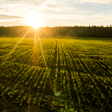
I have recently visited a village called kaliua district in Tanzania located at Tabora and study a lot of things about this village, includes environment, nature and people who are living there. Kaliua District is among the seven districts of Tabora region and was established on 2nd march,2012 and start functioning on 14th August 2013. Before that time,it was part of Urambo District. The area was then found to be too big to remain under the same District (Uranmbo) as it was hampering the delivery of quality administrative services. The headquarter of Kaliua District is located at Kaliua town,125 km from Tabora Municipal Council. The district shares borders with Urambo and Uyui district in the Eastern part, Mpanda and Mlele districts (Katavi region) on South, Uvinza and Kibondo districts (Kigoma region) on the West. The North side of the district is bordered with Ushetu (Shinyanga Region) and Bukombe (Geita region) in the North West. Land Area, Land Use Pattern and Administrative Units The Kaliua District has a total land area of 14,050 sq. kms which is about 18.82% of the total area of Tabora region. The arable land in district is 1,965.5 sq out of it only 1,500sq kms are actually cultivated annually. The remain 12,084.5 (86%) is forest reserve, normal grassland and water areas. The district vegetation is characterized with miombo woodlands natural forests mainly found in Igombenkulu, Milambo and Kanindo area. Out of the arable land in the district, only 1,500 sq. kms are actually cultivated annually, leaving the remaining 465.5sq. kms either lying idle for some reason such as soil leaching infestation, or being edges and river beds. About 10,535.58 sq. kms are forest reserves while normal forests/grassland used for grazing cover about 1,548.92 sq. kms. Climate With the exception of very few slopes, the district forms part of Central Plateau of Tanzania, relatively homogeneous with gently undulating plains intersected by seasonally flooded valley bottom soil. In the extreme north east, central and extreme south, this pattern gives way to open flat land suitable for cultivation and covered by well or moderately drained soils with textures of sandy loams. Soil The soils vary from sand or sand loam to sand-clay or loom-clay texture ?mbuga?. As follows:Rock and very Shallow Soil – These are mostly found on hills with slopes, very susceptible to erosion and suitable for grazing and fuel wood. These soils are found in Ichemba, Milambo, Igombe and Usinge wardsWell-Drained Sandy Soil – the soil texture is sandy and loamy or coarser within 100 cm of the surface, easily leached and therefore moderately fertile and responsive to fertilizer. They are well adapted to tobacco and maize production. Found in this area are Kaliua, Mwongozo, and Kamindo wardsWell – Drained Medium Mixture Soil –The soil colour ranges from red to yellow loamy sand and or clay loam. The soil has greater ability to retain nutrients and therefore potential for agriculture, but needs more water. It is found in some parts of Usinge ward, Ugunga and Ushokola.Upland Soil with Impeded Drainage – The soil is mostly saturated water within 100 cm of the surface long enough to restrict the range of crops that can be grown. Its texture range from sand to sandy clay suitable for paddy production. It is found in Ulyankulu, Kazaroho and Kaliua wards. Most of these soils have high nutrient contents and are considered suitable for a wide range of food and cash crops and therefore have the potential for profitable cultivation. Kaliua District soils can best be described as moderately fertile. Topography The district receives rainfall of between 900mm and 1,300mm annually, falling between the months of October or November and December and a dry season from January to February or March and a second lower peak occurs in February or March and the rains then tail off in April or sometimes May. Because of the low altitude, Kaliua District experiences tropical climate Drainage System Kaliua District forms part of the vast central plateau of Tabora region, an area of flat and gently undulating plains broken in places by small hills. Most parts of the district lie between 800 meters and 1,800 meters above sea level and form the main watershed separating rivers flowing south westward into the Zimbwe River. The district has however no permanent rivers although pools of water seem to remain after the long rains in the Igombe river located in the north and Ugalla river in the southern parts of the district. The district also has Lake Sagara on the Western side which forms the major part of the Malagarasi – Muyowosi Ramsar Site Core Zone.Agro – Ecological Zones,Basically the district has two distinctive agro-ecological zones, namely, the High Rainfall Zone and the LowRainfall Zone. High,Rainfall This zone covers western and southern parts of the district and parts of Ugunga, Ushokola wards. The terrain of the zone is low lying soil necessary for successful paddy cultivation and has been the paddy producing area of the district. Large parts of this zone have good tobacco potential, while the north is suitable for cotton. Soils are sandy loam and alluvial. This zone which is about 100 percent tsetse- free area has good range land and hence cattle rearing is carried out in this area. The main food crops grown in this zone are maize, paddy, groundnuts, sorghum, sunflower, cotton, sweet potatoes and tobacco. Cotton, tobacco, groundnuts, and sunflower are grown as cash crops. Maize and paddy are also sold to supplement income. Low,Rainfall This zone lies in the central, northeast and southeast part of Kaliua District and is covered with alluvial soils. It covers Kaliua, Mwongozo, Kazaroho and Kanindo wards. The zone has low rainfall of between 600 mm and 1,000 mm even though crops such as maize, millet, sunflower, sorghum, cassava, mangoes, beans, groundnuts are grown. Groundnuts, cotton, tobacco and paddy are grown as the major cash crops. A cattle rearing is practiced in this zone as it is a 100 percent tsetse-free area. Temperature The temperature ranges from 21 – 330C and highest temperature is experienced between August and October just before the start of rainfall. Temperature gradually falls in December, and then remains relatively constant up to May. From May to August the district experiences low temperatures. Vegetation Kaliua District is covered by Miombo woodlands mixed up with wetland vegetation of mbuga wooded grassland and mbuga grasslands. The Miombo woodlands are natural forests, which are found in Igombemkulu ward and some parts of Milambo and Kanindo wards. People?s awareness about weather In this district people are well educated about environment, they understands without protecting their environment they couldn?t be able to harvest, rainfall will not rain. Most of their agricultural activities depends on rainfall. Almost everyone has a bicycle to ride from one place to another unlikely other regions of Tanzania. References kaliua district photo courtesy Taken by me
|
   
|
|
|
|
|


 Previous : Community?s Contribution towar...


9 Comments
thanks for sharing
Posted 07-02-2018 10:04
good report
Posted 07-02-2018 10:02
Thanks for introducing the village to us, Peter! From your report, I assume you have learned and experienced a lot from the visit. It was a very informative one. Thanks again for sharing, and have a great day :)
Posted 02-02-2017 14:36
Nice photos Peter. and thanks for the reference.
Posted 27-01-2017 07:19
Good to know about it. Thanks for sharingabot this village.
Posted 26-01-2017 18:24
I wish I could discover there myself one day
Posted 26-01-2017 13:29
Thank you for Rolling about Kaliua village
Posted 26-01-2017 13:28
Thanks for introducing Kaliua distric. We could get to know so much about it through your vivid report.
Posted 26-01-2017 06:25
Thanks for introducing Kaliua distric Village in Tanzania. Your pics on a bicycle shows your green dedication. Keep it up!
Posted 23-01-2017 16:15