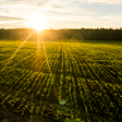
FOREST RESOURCES
Much of the Philippines is hilly and mountainous, with 52 percent of its total land area of 30 million hectares, equivalent to 15.8 million hectares, officially classified as forestland administered by the Department of Environment and Natural Resources.

Situationer:
- Of the country?s total land area of 30 million hectares, around 53 percent of it is classified as forestland, with slopes ranging from 18 percent and above. But not all is covered with forest cover.
- Based on the 2001-2003 satellite imageries, the country?s total forest cover is estimated at 7.168 million hectares, or 24.27% of the total land area. The remaining 8 million hectares are unproductive, open, denuded or degraded.
- Of the total forest cover, open forest accounted for more than half at 4.031 million hectares. The rest of the forest types contributed to the total as follows: closed forest at 2.56 million hectares (35.71%), plantation forest at 329,746 hectares (4.60%), and mangrove natural forest at around 247,309 hectares (3.45%).
- Historically, the country was known to harbor one of the world?s lush tropical rainforests. When the Spanish colonizers entered the archipelago in 1521, it was reported that 90 percent of the country?s total land area or 27 million hectares were covered with forest.
- About two years after the Americans substituted the Spanish sometime in 1900, the country?s forest cover was recorded at about 70 percent or 21 million hectares.
- Between 1934 and 1941, forest cover further declined to around 17 million hectares or 57 percent of the land area.
- A national inventory conducted in 1982-88 by the RP-German Forest Resources Inventory Project of the DENR Forest Management Bureau (FMB) estimated forest cover at 6.46 million hectares or 21.5 percent of the total land area in 1988.
- In the 1990 Master Plan for Forestry Development (MPFD) prepared by the Forest Management Bureau, it was estimated that the total forest loss between 1934 and 1990 was about 10.9 million hectares, equivalent to an average annual loss of 194,000 hectares.
- There are around 3,000 tree species known to thrive in the country, with 96 of them known to have medicinal values.
THE PHILIPPINE DUCK
The Philippine duck (Anas luzonica) is the country?s only endemic duck. It is classified as ?vulnerable? under the Red List of Threatened Species of the International Union for Conservation of Nature (IUCN).

Standing almost two feet high, the Philippine duck is a large dabbling or surface-feeding bird. Its food consists mainly of shrimp, fish, insects and some forms of vegetation in fresh- and saltwater habitats such as mangroves, rice fields and the open sea. It is typically a shy species that flies off quickly when approached.
Its crown, nape and eye stripe are black or dark brown its bill is blue-grey its head and neck are cinnamon in color and its body and legs are grayish-brown. Its spread wings show a glossy-green patch bordered with black and white on topside, and a white underside. Owing to its features, it has been dubbed as the ?tropical version of the mallard,? which is found in more temperate countries of America and Europe,
The breeding season of the Philippine duck is usually between March and November. A clutch may consist of as few as eight to as much as 16 eggs that are dull white with a brownish tinge. Its population, reported in the 2005 Asian Waterbird Census at 4,428, is on a continuing decline, hence its classification as a vulnerable species.
The decline in its population is attributed to hunting and trapping, destruction of its habitat due to conversion of natural wetlands and mangroves, and pollution from extensive use of pesticides in rice fields. Fortunately, the Philippine duck breeds well in captivity.
The Philippine duck, as with other wildlife, is protected by Republic Act 9147 or the Wildlife Resources Conservation and Protection Act. RA 9147 promotes ecological balance and enhances biodiversity by conserving and protecting wildlife species and their habitats.
To date, two areas have been declared by the Department of Environment and Natural Resources (DENR) as critical habitats of this bird: a 27-hectare wetland area in Cabusao, Camarines Sur, and the 178-hectare Malasi Tree Park and Wildlife Sanctuary in Cabagan, Isabela.
However, the duck has also been reportedly sighted in other areas such as Caylabne Bay in Cavite Mt. Iglit Baco and Naujan Lake in Mindoro Island Maria Aurora Memorial Natural Park in Aurora Bataan Natural Park Subic Bay Forest Reserves Olango Island in Cebu and Candaba Marsh in Pampanga.
MYSTIC MT. BANAHAW
Mts. Banahaw-San Cristobal Protected Landscape (MBSCPL) is site of the famed mystic mountain Mt. Banahaw. The MBSCPL straddles the provinces of Laguna and Quezon in the Southern Tagalog Region.

?span style="font-size: 7pt font-family: 'Times New Roman'"> The MBSCPL has a total area of 10,900.59 hectares. It covers eight municipalities and two cities, namely: Dolores, Candelaria, Sariaya, Lucban and Tayabas City, all in Quezon province and Majayjay, Nagcarlan, Liliw, Rizal and San Pablo City in Laguna. It was declared as a protected landscape under Republic Act 9847 signed on December 11, 2009 by then President Gloria Macapagal Arroyo.
Mt. Banahaw is a dormant volcano and is the highest mountain in the Southwestern Luzon volcanic region. Its three peaks are the Mt. Banahaw de Tayabas, Mt. Banahaw de Dolores, and the Mt. Banahaw de Lucban, a high conical peak flanking the mountain?s northeastern side and is separated by a deep valley gorge and a crater lake called Dagat-dagatan.
Mt. San Cristobal, on the other hand, lies on the northwestern side. It is connected to Mt. Banahaw through a narrow saddle passing through a portion of Dolores town in Quezon.
Extremities in elevation within MBSCPL have allowed the formation of a wide range of habitats, from the steep ridges down to the flat plains of the lowlands. This explains why its mountain ranges support a high diversity and endemicity of floral and faunal species. Among such are the Rafflesia philippensis or Rafflesia banahawensis, the largest flower in the world palms that are sources of handicraft materials, palm wine and furniture making newly-discovered species of forest mice several species of reptiles such as skinks, lizards and snakes amphibians, particularly frogs and butterflies.
MBSCPL serves as a watershed for the plains of Laguna and Quezon, supplying water for domestic, agricultural and industrial uses. It has been a setting for Philippine historical events and is a favorite site for campers, trekkers and bathers, as well as for spiritual worshipers. Mt. Banahaw itself is said to have ?healing powers?, a source for ?herbularios? who get plant parts said to have medicinal properties.
Because of the stresses caused by human visitors, the MBSCPL Protected Area Management Board (PAMB), which is composed of representatives from various stakeholders, issued on March 9, 2004 Resolution No. 001-2004. This was a closure order on selected sites or areas within the MBSCPL due to degraded vegetation caused by trekkers and pilgrims, the presence of coliform bacteria in its waters, and tons of garbage and trash.
Later, the moratorium was extended, initially for three years, from 2005 to 2008 then again from 2009-2012. Although vegetation has regenerated and the garbage has lessened, the PAMB has decided to extend further the moratorium for another three years, from 2012 to 2015, to allow the natural environment to heal itself.
SAVING PHILIPPINE FOREST
When the Spaniards came to colonize the country, our land was bursting with lush forests, occupying around 90 percent of the total land area of 30 million hectares. Forest trees then comprised of more than 2000 species, majority were indigenous or endemic to the country.
Decades of mismanagement, however, turned a big chunk of our forestlands (about 8 million hectares) unproductive, denuded or degraded. Thus, the National Greening Program (NGP) was conceived to bring back the lush vegetated cover of the uplands by involving the citizenry, particularly the students and government employees. But other sectors are also encouraged to join in the effort as, like other nations in the world, the Filipino people remain our most important national asset capable of reviving the lost green gold of the country.

Launched in May last year by no less than President Aquino by virtue of Executive Order No. 26, the NGP seeks to plant some 1.5 billion trees covering a land area of 1.5 million hectares over a period of six years from 2012-2016.
Of the 1.5 billion tree seedlings, 50 percent shall be forest trees. The other half shall be agro-forestry, or a mix of fruit and forest trees to support the livelihood of some six million upland families in identified areas in Luzon, Visayas and Mindanao.
The NGP envisions to achieve its target by mobilizing some 14 million elementary students and about seven million high school students nationwide. Government employees numbering some 1.5 million nationwide will also be tapped in the program. Each one is mandated to plant at least 10 seedlings each year throughout the program period.
Under the principle of Public-Private Partnerships (PPPs), the DENR will also be tapping the engagement of private establishments, companies and industry associations in the greening effort as part of their Corporate Social Responsibility (CSR).
But, unlike previous greening initiatives, the NGP has been designed to address three key areas of development - human development, economic development, and environmental protection.
Under human development, NGP targets food security, including sufficient water supply, economic empowerment, as well as ecological stewardship by involving target people?s organizations and indigenous peoples as vanguards of forest resources.
Under economic development, NGP advocates for increased and sustainable supply of forest-based raw materials increased productivity of idle lands (value creation) increased economic activity in the uplands and optimized utilization of upland resources, while avoiding "kaingin-making" or the so-called ?slash and burn? agriculture and other destructive practices.
On environmental protection, the NGP hopes to address environmental productivity and stability climate change mitigation and adaptation and biodiversity conservation.
Among the priority areas for rehabilitation under the NGP include mangrove and protected areas, ancestral domain areas, civil and military areas, urban areas under the greening plan of LGUs, inactive and abandoned mine sites, and all other suitable lands for reforestation
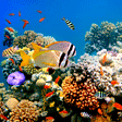
APO REEF NATURAL PARK
The 34-square kilometer Apo Reef in Occidental Mindoro is the second largest contiguous coral reef in the world and the largest in the country. It is on the tentative list of UNESCO World Heritage Sites.
The Apo Reef Natural Park lies approximately 33 kilometers off the coast of Sablayan in the province of Occidental Mindoro. The coral reefs cover a total area of 34 square kilometers, making it the second largest contiguous coral reef in the world, next only to the Great Barrier Reef of Australia.

Also considered as the second largest atoll-like reef in the country, Apo Reef consists of two separate coral reefs that are separated by a 30-meter deep channel with a fine white sand bottom, numerous mounds and patches of branching corals under the deep blue water.
Three islands comprise the Apo Reef Natural Park. Apo Menor or Binangaan Island is marked of limestone rock with few vegetation. Cayos del Bajo Island is a coralline rock formation with no vegetation. Apo Island, the largest of the three at 22 hectares, features a shallow lagoon surrounded by a mangrove forest that benefit many of the coastal and marine species in the area, as well as a sanctuary for sea birds.
It is in Apo Island where park rangers who patrol the reef?s boundaries have put up their quarters, as well as basic amenities for visiting divers – except potable water or electricity. It also features a historic lighthouse that dates back to the Spanish Colonial Period.
The Apo Reef Natural Park, including its peripheral buffer zone, is a marine sanctuary and is thus a ?no-take zone?. This means fishing within the reef is banned. It is a popular site for tourists, who bask in its fine white sands, leisurely stroll along boardwalks within the mangrove area, or marvel at the extremely diverse coral species and other marine life that include sharks and rays.
The Apo Reef was proclaimed as a protected area under the category of Natural Park by virtue of Presidential Proclamation No. 868 issued in 1996. In May 2006, the DENR?s Protected Areas and Wildlife Bureau (PAWB) submitted the reef for consideration as a World Heritage Site of the United Nations Educational, Scientific and Cultural Organization (UNESCO).
Its protection and conservation is a joint effort of the DENR, the local government unit, and civil society.
WETLANDS
Wetlands are areas that are permanently or seasonally saturated by water, enough to support vegetation that can adapt to saturated soil conditions. The science of wetlands is known as paludology. February 2 of every year is celebrated in the Philippines and rest of the world as Wetlands Day to highlight the importance of wetlands to man.
The basic function of wetlands is to conserve and provide water, constituting economic, scientific, cultural and recreational value for the community. They play a vital role in climate change adaptation and mitigation. Their other functions are:
- as water purification systems
- to regulate water flow and precipitation, and act as flood control system
- provide shoreline stability
- serve as reservoirs of biodiversity

Wetlands can be natural or man-made. Natural wetlands include swamps, marshes, lakes and rivers, deltas, oases, estuaries, peatlands, mangroves and coral reefs. On the other hand, fish ponds, rice paddies, dams or reservoirs, and salt pans can be considered as man-made wetlands.
Encroachment on, or loss of, wetlands can cause serious environmental damage to the ecosystem, so they should be restored and rehabilitated when possible. They should be conserved through ?wise use?, which the Ramsar Convention on Wetlands defines as ?the maintenance of their ecological character, achieved through the implementation of ecosystem approaches, within the context of sustainable development.?
The Ramsar Convention is an intergovernmental treaty that provides the framework for national action and international cooperation for the conservation and wise of wetlands and their resources.
In the Philippines, there are to date four sites identified as ?Wetlands of International Improtance? or simply called Ramsar Sites. These are the Agusan Marsh Wildlife Sanctuary in Mindanao the Naujan Lake National Park in Oriental Mindoro the Olango Island Wildlife Sanctuary in Cebu and the Tubbataha Reefs National Marine Park in Palawan.
The world marks February 2 each year as World Wetlands Day, marking the date of the adoption of the Convention on Wetlands in Ramsar City in Iran on February 2, 1971. The Philippine government adopted its local celebration in 1999 with Presidential Proclamation No. 74, ?Declaring February 2 of every year as National Wetlands Day.?
PILI: THE NEXT ?TREE OF LIFE?
Because all of its parts have immense use for man, the pili tree is fast gaining fame as the ?tree of life?, next to the coconut tree.
Pili belongs to the Canaruim genera of the Burseracea family. It is believed that there were 53 species of the Canaruim genus that used to thrive in the Philippines, but its number has been reduced to nine. At present, the two most commercially-important species are the Canarium ovatum and Canarium luzonicum.

The pili fruit has a thin skin, a pulpy middle and a hard core part that contains its kernel. The fruit is usually 4 to 7 centimeters long, 2 to 4 centimeters in diameter, and weighs 15 to 45 grams. Its kernel - rich in magnesium, phosphorous, potassium, calcium, ascorbic acid, riboflavin, zinc, copper, iron, sodium, thiamine and niacin - can be eaten raw, or roasted. Its pulp is also pickled or cooked. Boiled pili pulp resembles the sweet potato in texture and is considered to have food value similar to that of avocado.
Processed pulp yields edible oil used for cooking or as a substitute for cottonseed oil in the manufacture of soap and edible products. The leaves are used for salads and as relish. It is also a nutritious feed for cattle and swine. Its hardy shell is used in handicrafts or for charcoal, firewood and as medium for growing orchids and anthuriums. The trunk is an ideal material for quality furniture, wood panels and doors.
But, perhaps, its most desirable part is its sap from which a valuable resin called elemi is tapped from the bark. Even without tapping, the pili tree naturally exudes its resin from its bark and roots.
The elemi can be sourced from both species, although the C. ovatum is used more for harvesting the pili kern which have higher nutritive and commercial value while C. luzonicum trees have higher sap yield but of lesser quality pili kernels. Hence, much of the resin obtained is from the trunk of C. luzonicum.
Locally known as ?salong, sahing, pulot or pilit,? the elemi gives out an essential oil called limonene, which is used in the manufacture of perfumes because of its lasting aroma that blends well with lavender, rosemary, frankincense, sage, myrrh, patchouli, vetiver and other international fragrances
Elemi generally refers to a variety of resinous products obtained from different countries especially in the Southeast Asian region, but the Food and Agriculture Organization (FAO), in its Corporate Document Repository titled ?Gums Resins, and Latexes of Plant Origin,? lists the Philippines as the only source of internationally traded elemi as it is preferred by major players in the world perfumery industry, thus, the name ?Manila elemi?.
Manila elemi is the fragrance component used in luxury perfumes and skin conditioners of some international brands.
Due to its consistency and low volatility when dissolved in water, the limonene essential oil of Manila elemi is also a favored component of water-based aromatic scent used in air fresheners, stationeries, tissue papers, ballpen inks, coatings, candles and cosmetics.
Its aromatic scent can be described as fennel and dill-like with citrus and woody notes. A kilo of the pili resin can sell at least P70 per kilogram.
Agroforestry crop
In its effort to bring back the honor as the ?land of pili?, local governments in the Bicol region, particularly Camarines Sur, has launched a massive planting of the species under the National Greening Program.
PHILIPPINE EAGLE
The Philippine Eagle (Pithecophaga jefferyi) fits a lot of superlatives as a bird of prey: one of the world?s largest, tallest, most beautiful, and most powerful birds. However, it is also one of the rarest and most critically endangered.

Called by American aviator Charles Lindbergh as the world?s ?noblest flier,? the Philippine Eagle was once known as the monkey-eating eagle because of earlier reports that it preyed solely on monkeys. However, this bird actually sits on top of the food chain, with other animals such as flying lemurs, squirrels, snakes, monitor lizards, bats and owls forming part of its diet.
The Philippine Eagle is recognizable with its unique head crest resembling a lion?s mane, adding to its majestic appearance and earning for it the name Haring Ibon (Bird King). Its keen daytime eyesight which can be four to five times stronger than a human?s perfect vision, sharp hooked talons, dagger beak, and a flight that is fast and agile, uncharacteristic for such a large bird, all make for a very dangerous bird of prey.
On the average, Haring Ibon ranks second to the Harpy Eagle of Central and South America in terms of weight (eight versus nine kilograms). As the tallest eagle, it measures more than one meter from the tip of the bill to the tip of the longest tail feather. Its wings have the largest surface area among all eagles in the world, with its wingspan exceeding two meters in length.
The International Union for Conservation of Nature (IUCN) estimates about 500 mature individuals, mostly found in Mindanao and with the rest sighted in Samar, Leyte and in the Cordillera and Sierra Madre mountain ranges in Luzon. Its decreasing population in the wild is further threatened with uncontrolled hunting, loss of habitat due to forest destruction, and pollution. It is also monogamous and can lay only one egg in two years. Since 1994, the IUCN has classified the Philippine Eagle as ?critically endangered? in its Red List of Threatened Species.
The Philippine Eagle is the flagship species of the Philippine Raptors Conservation Program implemented by the Protected Areas and Wildlife Bureau of the Department of Environment and Natural Resources (DENR-PAWB) in 10 regions nationwide. The program?s output include an established database on the population distribution of the Philippine Eagle to have their outputs proclaimed as protected area to release captive-bred raptors in the wild and to enjoin the participation of surrounding communities in wildlife conservation activities.
Some of the efforts that have been undertaken to conserve this majestic eagle are the following:
- Declaration of the Philippine Eagle as the country?s national bird through Presidential Proclamation No. 615 signed by then-President Fidel Ramos on July 4, 1995
- Declaration of June 4-10 of every year as ?Philippine Eagle Week? through Presidential Proclamation No. 79 signed by then-President Joseph Estrada on February 24, 1999
- Depiction of the Philippine Eagle at least 12 times on Philippine postage stamps and on coins to increase information dissemination
- Proclamation of natural habitats such as Northern Sierra Madre, Mt. Kitanglad and Mt. Apo as protected areas
- Establishment of the Philippine Eagle Foundation, which runs the Philippine Eagle Center in Davao City to oversee captive breeding efforts and an reintroduction program as well as the monitoring and conservation of wild populations
LAND RESOURCES
The total land area of the Philippines is about 30 million hectares, half of which is classified as forestlands, 47% as alienable and disposable lands, and the remaining 3% as unclassified forestlands.

Situationer:
- The country?s total land area of 30 million hectares is legally classified as alienable and disposable land and forestland.
- As of 2008, classified forestland covers some 15.05 million hectares or 50% unclassified forestland, 0.755 million hectares or 3% and alienable and disposable land (A & D) spans 14.19 million hectares or 47%.
- Of the country?s 14.19 million hectares of A & D lands, 9.63 million hectares are already titled.
- The survey, management, and disposition of A & D lands, including government lands not placed under the jurisdiction of any specific government agency, is a mandate of the Land Management Bureau, one of six bureaus of the Department of Environment and Natural Resources.
- Among the major activities of the LMB include the conduct of cadastral survey of all municipalities and cities in the country, management of foreshore areas, and processing and issuance of land titles, as well as investigation and resolution of land cases involving rights conflicts of public land applicants.
MIGRATORY BIRD SITES
Candaba Swamp in Pampanga is an important staging and wintering area for ducks and other threatened waterbirds. As part of the East Asia-Pacific Migratory Flyway, the Philippines has 117 Important Bird Areas (IBAs) covering 32,302 square kilometers that act as refuge for as many as 115 globally threatened species of water birds.

Driven by sheer instinct to save their own species, many animal species, especially birds, make an annual escape from the cold winter of the temperate regions to the welcoming warmth of the tropics to feed and breed. In the Philippines, the peak months for birds migrating to the South are usually from September to November, while those traveling North often occur between February and April.
IBAs are key sites for conservation. They hold significant numbers of one or more globally threatened species, and can be a habitat – though temporary – to exceptionally large numbers of migratory or congregatory species. Some of the migratory bird species spotted in Philippine bird sites are egrets and herons (Ardeidae family), ducks (Anatidae family), and the endemic Philippine mallard (Anas luzonica).
Often, IBAs are already part of protected areas. Among the 117 IBAs identified by Birdlife International, 47 are protected, 23 are partially protected, and 47 are unprotected. (Birdlife International is a global partnership of conservation organizations that strives to conserve birds, their habitats and global biodiversity.)
Migratory bird sites are often threatened by human activities, such as overexploitation and conversion of ecosystems for development purposes.
The DENR, through the Protected Areas and Wildlife Bureau, closely works with organizations of bird watchers and other wildlife enthusiasts to protect migratory bird sites
MANGROVE FORESTS
Mangrove forest is also known as the ?rainforest of the sea.? It grows well in tropical countries, including the Philippines. Mangroves are an important part of the coastal and marine ecosystem that includes the seagrass and the coral reefs. Of the world?s more than 70 mangrove species, around 46 species are known to occur in various parts of the country.

Mangroves provide economic as well as ecological benefits, such as the following:
?span style="font-weight: normal font-size: 7pt font-family: 'Times New Roman'"> they are a good source of products like alcohol, medicine, tannin, charcoal, timber and housing materials
?span style="font-weight: normal font-size: 7pt font-family: 'Times New Roman'"> they support fisheries production and aquaculture
?span style="font-weight: normal font-size: 7pt font-family: 'Times New Roman'"> they provide nursery grounds, shelter and food for fish and other sea creature
?span style="font-weight: normal font-size: 7pt font-family: 'Times New Roman'"> they protect coastal communities from storm surges, waves, tides and currents
?span style="font-weight: normal font-size: 7pt font-family: 'Times New Roman'"> they act as carbon sink by reducing organic pollution along shore areas
?span style="font-weight: normal font-size: 7pt font-family: 'Times New Roman'"> they serve as recreational grounds for wildlife enthusiasts and
?span style="font-weight: normal font-size: 7pt font-family: 'Times New Roman'"> they stabilize the coastline by reducing erosion.
Though mangroves are faced with natural dangers like typhoons, pests and diseases, and rising sea levels due to global warming, their biggest threats are man-made. Human treats include:
?span style="font-weight: normal font-size: 7pt font-family: 'Times New Roman'"> conversion of mangroves to fishponds and salt beds
?span style="font-weight: normal font-size: 7pt font-family: 'Times New Roman'"> reclamation of mangrove areas for developments such as piers, airports and housing
?span style="font-weight: normal font-size: 7pt font-family: 'Times New Roman'"> pollution and siltation from upland communities and
?span style="font-weight: normal font-size: 7pt font-family: 'Times New Roman'"> human disturbance, overexploitation and utilization, such as over-cutting for firewood purposes.
In the DENR, management of mangrove areas is a mandate of the Coastal and Marine Management Division of the Protected Areas and Wildlife Bureau (PAWB).
WATER RESOURCES

Water is an essential element to our everyday existence. Its role is vital in the sustenance of all life forms, as well as in agricultural, industrial, households, recreational and environmental activities. As population continues to rise, so does the demand for fresh water too. Water is a major factor shaping the natural environment. It has a long-term influence on the vegetation, fauna, and shape of the landscape and on various ecosystems.
- 1,830 sq kilometers of Philippine rivers and lakes cover 61% of the country?s total land area
- 50,000 sq kilometers of groundwater reservoir is recharged by rain and seepage from river and lakes
- 421 principal river basins, of which 20 are considered major river basins
- 53,943 million cubic meters estimated annual discharge of Cagayan River, the longest and largest river in the Philippines, with a ground water reserve of 47,895 million cubic meters
- 79 lakes mostly utilized for fish production
- 86% of piped-water supply systems that use groundwater as a source
- 146 billion cu.m estimated amount of the country?s water supply
- 6.1 million liters per second (lps) total allocation of water for different uses
- 1.06 million lps surface water allocated for power generation in Region 2, the largest in the entire country
- 12, 879 lps groundwater allocated for municipal use in Region 4, the largest in the entire country
- 207 million cu meters projected water consumption in Metro Manila by 2010
- 59 natural lakes and more than 100,000 ha of freshwater swamps
- There are four major groundwater reservoirs (Cagayan, 10,000 km2 Central Luzon, 9,000 km2 Agusan, 8,500 km2 Cotabato, 6,000 km2) which, when combined with smaller reservoirs already identified, would aggregate to an area of about 50,000 km2
- A survey of surface water storage potential has identified sites for 438 major dams and 423 smaller dams
- As estimated 146,000 MCM total water resource potential
- 438 major dams and 423 smaller dams (total of 861 impounding dams and reservoir sites) identified sites of water surface water storage potential
PROTECTED AREAS
The Philippine government established a system of protected areas—ranging from large natural parks, to landscapes and seascapes, to wildlife and marine life sanctuaries—for conservation and management of the ?last remaining representatives? of Philippine habitats and ecosystems.

- 109 protected areas established under the National Integrated Protected Areas System (NIPAS) covering 3.50 million hectares or 11.67% of the country?s total land area
- 29 marine protected areas covering 1.37 million hectares
- 80 terrestrial protected areas covering 2.13 million hectares
- 12 protected areas established by the Philippine Congress
- 3,143.6 meters above sea level, Mt. Apo Natural Park?s highest elevation, the highest mountain in the Philippines and one of the country?s most popular climbing destinations
- 359,486 hectares biggest land area of a protected area - the Northern Sierra Madre Natural Park
- 4.02 million hectares total land area of all protected areas in the country including those initial components which have not been placed/proclaimed yet under the NIPAS as well as protected areas with both land and marine components
SOURCE:
ENGR. ALEX C. LUIS, MSCE


 |
| 


 Previous : Characteristics of Water


5 Comments
Thanks Carlos about your informative report about Philippines natural resources and it's present scenario.Hope that this richness in biodiversity will only grow in coming day's.
Posted 30-09-2014 13:22
Natural resources all need to be protected for present and future. Always think many times while doing anything on nature is it ecofriendly
Posted 28-09-2014 01:11
Carlos, your vivid description & the pictures provided are excellent. Deforestation is a common issue in all green nations. It's the human tendency to misuse, overuse & abuse the nature. That has brought us to this peril stage.
We all raise our voices to curd this menace & keep the mother earth green & greener.
Posted 22-09-2014 14:19
Thanks for the elaborate report on Philippines biodiversity. Pictures are beautiful. Forest decline statistics are really alarming. Hope authorities come up with laws and measures to conserve forest , other landscape and Philippines wide biodiversity.
Posted 22-09-2014 02:07
Thank you for your extensive information on the natural resources of Philippines. It's interesting to see how rich Philippines is in them, and yet has not made use of them fully. Hopefully Philippines will develop infrastructures necessary for exploiting them. Good work!
Posted 21-09-2014 23:01