Environmental Networking Platform for Children and Youth by SAMSUNG E&A


Stay connected with Eco-generation :


| Share  |
| 
- Home >
- Our Actions >
- Ambassador report
10
Comments
GIS and the Climate Change |
|---|
|
by Sandhya Adhikari | 28-07-2020 02:12
|
|
GIS that stands for Geographical Information System is the technological tool for comprehending geography by collecting, storing, manipulating data and providing the spatial analysis based on location. GIS uses software, hardware and data for capturing,managing, analyzing as well displaying every geographical information. It manages the data in such a form that a person who reads a map can easily select and use it in a necessary. GIS has a multidimensional function from data capture, data management, data manipulation, analysis and presenting in both visual graphic and report form by utilizing inherent characteristics of spatial data.
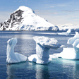
According to NASA, the average Earth’s temperature has increased by approximately 1.62 degree Fahrenheit since 19th century, Scientists attribute problems like extreme weather events, rising sea levels and diminished ice sheets and glaciers to the emission of carbon dioxide and other greenhouse gases into the atmosphere. The Fourth National Climate Assessment, released by the U.S. Global Change Research Program in November 2018, predicted long-term consequences such as · Worsening air quality · A decline in crop production · Greater incidence of food and waterborne diseases · An increase in heat-related deaths in the U.S. · Diminished populations of underwater creatures due to ocean acidification Thus through the use of GIS expert can possibly reduce and monitor these problems, By bringing together GIS and climate change studies, spatial problem-solvers can seize opportunities to make a difference in the lives of future generations.
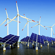
GIS application is fundamental in various field. With the help of GIS, the plotting of weather pattern all across the globe can be done which assists the scientist to predict how the particular area is going to be affected with the particular weather phenomenon. The geographic effect don’t exist in the bubble form, they have knock on effect. GIS can predict the upcoming calamities like flooding, drought, hurricans, tornadoes etc. By taking the historic data and current records , GIS can predict potential future changes to global temperatures, sea rises and global warming. Through spatial analysis we can make clear prediction of the what will the possible issues that we are going to face and what future may look on global scale. Climate change is the natural geographic circumstances which requires a geographic solutions. Thus through GIS users represent a vast knowledge, expertise and best practise in applying this cornerstone technology to the science of climate change and understanding its impact on natural and human systems. Addition to this implement in the field of climate change monitoring, carbon management, in disaster management along with identification of current and future risk and vulnerabilities of climate change, and so it is helpful for design and implementation adaptation operations. GIS technique assists in forest carbon mapping as a result of which reduce in the deforestation and reduce the carbon dioxide. GIS is the key components for forest carbon monitoring which the developing countries are in need to manage their forests. GIS help in climate modeling because of which the upcoming crises can be reduced, this is the key tools to know how our world was in past, is in present and will be in future. With this Scientists can determine the perfect places for harnessing alternate energy, mapping resources such as wind, and solar energy. GIS plays a major role in maintaining green community, which assists in visualizing existing green space, analyze carbon emission and sequestration and make a sound decision for any ecological activities.
To sum up, in the context of this technocrat world, technological application is of vast importance for efficient and effective work. GIS technology have set up mapping as a crucial means of identifying connections between the state of the climate and other area of concern, climate scientist gather vast amount of data to study the environmental conditions and problems to investigate the solutions, Thus GIS is considered as one of the crucial tool for the geographical consequences.
(P.S: I am very glad to share with you all that during this lockdown period, I got an opportunity to have training on ARCGIS, and my curiousity has level up for GIS, remote sensing and spatial analysis. Now I am learning various map making process, geoprocessing, buffer, interpolation and soon will learn QGIS, Cartography, I had also prepared some map on agriculture field, and in near future I am planning to work for climate change data). References: http://www.esri.com/library/bestpractices/climate-change.pdf http://www.climate.gov/teaching/resources/exploring-ncar-climate-change-data-using http://gis.usc.edu/blog/hot-or-cold-how-gis-changes-our-perceptions-of-climate-change/ http://www.researchgate.net/publication/260481535_GIS_Applications_in_a_Changin
|
|
|
|
|


 Previous : [Free Report] Oceans of Movies...


10 Comments
Hello Sandhya,
This is another amazing writing of yours I read today. Thank you.
Regards
Posted 13-08-2020 13:27
Greetings from South Korea!
I hope you are doing well
Amazing report!
Stay motivated!
Green cheers
Regards
Dibya Bhatta
Posted 04-08-2020 16:14
Hello Sandhya
Greetings and Namaste from Nepal
Wishing you a safe stay
Thank you for your report on GIS and the Climate Change
Keep writing great reports.
We are eager to read more reports from you.
Green Cheers :)
Best wishes,
Kushal Naharki
Posted 03-08-2020 20:21
Hi Sandhya Adhikari, this is a mentor, Sang Su Lee.
Thank you for introducing some benefits and detailed mechanisms of GIS! Technological improvement is really important because it can let people predict and allows us to prepare for the future based on the prediction. It is so unfortunate that the global temperature is continuously rising, but I really hope that using GIS will help us to combat this issue.
Green cheers~
Posted 02-08-2020 00:08
Thank you @Taehyun Mentor for your words.
Posted 29-07-2020 11:56
Hello Sandhya Adhikari, this is mentor Taehyun!
Thank you for reading this useful article about GIS systems! GIS technology is becoming very important in the 21st century, and many countries are scrambling to build a GIS system on their territory. In particular, satellite systems, which are almost essential to building GIS systems, are considered to be very important, as if they were confidential technology in each country. I think the map created by overlaying GIS and various satellite observations can create a lot of added value by itself, which is an interesting topic! I think it will be a good tool to help you systematically protect your environment!
Thank you for the report!
Green cheers!
Posted 29-07-2020 00:39
Thank you @Emerson for your words.
Posted 28-07-2020 19:58
Thank you @Aarati khatri for the words
Posted 28-07-2020 19:57
Greetings Sandhya!
I hope you are doing fine and is safe wherever you are.
In this era of science and technology, The GIS like advanced tool can be used to solve various burning environment issues like climate change, flood mapping , landslide if used with proper guidance.
Thank you so much for sharing the informative article.
Posted 28-07-2020 09:35
Hello Sandhya!
Thank you so much for sharing this article. Climate change is an increasingly pressing issue, so it is important to have young activists be interested in technologies like the GIS system. It is also so cool that you will be learning QGIS photography! Keep up the good work :).
Posted 28-07-2020 05:17